Summer 2025 – Low water levels
Many canals and rivers are currently affected by low water levels caused by the current drought conditions in the UK. You can check a summary of which waterways are affected here and more detailed information on the CRT website .
The Aire & Calder Navigation and Yorkshire Waterways
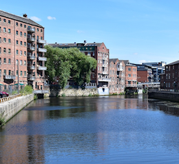
The Aire and Calder Navigation runs for 34 miles from the lively city of Leeds across the wide, flat fertile fields of east Yorkshire to the inland port of Goole. The high banks and flood gates may remind you that this is still a river at heart, made navigable over hundreds of years. The automated manned locks and large trading craft can tell you this is still a busy commercial waterway, despite the demise of many traditional industries. And the marinas, moorings and smaller boats also show it is an increasingly popular waterway with leisure boaters, partly because of the network of cruisable waterways it opens up.
The Aire & Calder Navigation
Leeds Dock once was a busy junction with the Leeds and Liverpool Canal but became full of derelict waterside wharves and buildings. Recent waterside developments mean there’s lots to explore and enjoy. Drop down Leeds Lock and a within a few miles the Wakefield branch joins near Castleford, coming down from a junction with the Calder and Hebble Navigation.

ON THESE WATERWAYS…
The flat landscape around Ferrybridge had been dominated for most of the twentieth century by the chimneys and huge cooling towers of three generations of electricity power stations. However the last was closed in 2016 as coal burning was phased out, and the final towers were flattened in 2022. (Three had already been blown down by gales in 1965.) Coal transport to the power stations had been a major traffic, eventually using 170 ton compartment boats which were emptied by a huge ‘tippler’, but rail had taken over much of the work years before the closure. Near Nottingley the peaceful Selby Canal heads north to join the River Ouse while the Aire and Calder takes a straight line towards to Goole across wide flat farmlands with few villages or deviations, except where it begins to run alongside the Dutch River. The very straight five mile New Junction Canal was a late 1905 development to give cities such as Doncaster, Sheffield and Barnsley on the Sheffield and South Yorkshire Navigations a better link to the sea. Goole, the Aire & Calder’s eastern terminus, is well worth a visit, a fascinating inland port with docks still busy with sea going craft.
Continuing development is a common theme to many Yorkshire navigations, unlike most of our canals which remain almost unchanged since the eighteenth century burst of ‘canal mania’. The huge value and range of potential trade, within Yorkshire and also, via the Ouse and Humber, along coasts and across the North Sea, ensured plentiful investment in these Yorkshire waterways. From the seventeenth century developments were ongoing; waterways were widened, deepened and straightened, locks enlarged and automated and handling methods increasingly mechanised. All so heavier cargoes could be be handled more quickly and efficiently.
The Selby Canal
Built in 1778 to bypass a meandering section of the River Aire near Nottingley it descends 4 locks in 12 fairly straight miles to join the River Ouse at Selby, which became a busy inland transshipment port. However in 1826 the Selby Canal was itself bypassed when 18 miles of new canal was built from Knottingley to a new inland port at Goole, much lower down the Ouse than Selby.
-

Lockmaster Map No.3 - Pennine Waters East
£5.5 Add to basket -

Lockmaster Map No.4 - South Yorkshire's Waterways
£5.5 Add to basket -
Lockmaster Map No.1 - North Yorkshire's Waterways
£5.5 Add to basket -

Imray - Inland Waterways of Great Britain Guide
£32.5 Buy on Amazon -

Imray - Map Inland Waterways of Great Britain
£9.95 Add to basket
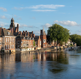
The Yorkshire River Ouse
The Ouse flows off the North Yorks Moors through the medieval city of York and on for over sixty navigable miles before emptying into the Humber Estuary. It has been a trading river since Roman times, it’s now a popular leisure waterway, especially around York and above were it becomes the River Ure and the short restored Ripon Canal with its historic city centre basin. Below York after Naburn Lock the Ouse becomes increasingly tidal and must be navigated with care.
The River Derwent
A tributary of the Ouse and navigable with care for about 12 miles from the tidal Ouse up to a junction with the Pocklington Canal where the river channel becomes overgrown. The river was tidal up to Stamford Bridge until the 1970s when a barrage and lock was built at its junction with the Ouse at Barmby to enable water abstraction. Seven miles of the once derelict Pocklington Canal to the Bielby Arm are now reopened thanks to the Pocklington Canal Amenity Society.
All materials and images © Canal Junction Ltd. Dalton House, 35 Chester St, Wrexham LL13 8AH. No unauthorised reproduction.
About
| Terms
| Privacy |
Returns |
Sitemap
| Contact Us
Web Hosting & Development
With over 800 pages, this website uses cookies to record visitor behaviour using Google Analytics. More information on Privacy Page. Page last updated: 11/11/2025.
Back to Menu....
Canal Maps & Guides >>